Key Takeaways
- South Base Camp (5,364m) does not offer a direct view of Mount Everest’s summit because Nuptse’s western ridge physically blocks the line of sight from the camp floor to the peak.
- Kala Patthar (5,644m), located 1.5 kilometres from Gorakshep, provides the most celebrated and accessible direct view of Everest on the entire EBC trek route.
- The Khumbu Icefall, Nuptse, Lhotse, and Changtse are the dominant visual features at South Base Camp, and each delivers a scale of mountain scenery that rivals any viewpoint on the trek.
- North Base Camp in Tibet (5,150m) offers an unobstructed face-on view of Everest’s north wall, making it the only base camp where the summit is directly visible from the camp itself.
Table of Contents
You cannot see Mount Everest’s summit from South Everest Base Camp in Nepal. Nuptse’s western ridge, rising to 7,861 metres, blocks the direct line of sight from the camp floor at 5,364 metres to Everest’s 8,849 metre summit. The closest accessible viewpoint for a clear Everest summit view is Kala Patthar at 5,644 metres, a 2 to 3 hour climb from Gorakshep on the standard EBC trekking route.
The Short Answer: No, You Cannot See Everest from South Base Camp
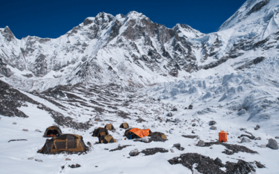
South Everest Base Camp sits on the Khumbu Glacier at 5,364 metres in the Khumbu region of northeastern Nepal. The camp occupies a glacial moraine basin surrounded on three sides by the walls of Nuptse, Lhotse, and the Khumbu Icefall approach to the Western Cwm. Everest’s summit rises 3,485 metres above the camp, but the peak itself sits behind the Nuptse ridge from the perspective of anyone standing on the camp floor.
Why Nuptse and the Khumbu Valley Block the View
Nuptse stands at 7,861 metres and forms the western wall of the upper Khumbu valley directly above Base Camp. From the camp’s position on the glacier, Nuptse’s ridge intercepts the visual angle to Everest’s summit at every accessible point within the camp perimeter. A trekker standing at Base Camp and looking toward the direction of Everest sees Nuptse’s rock and ice wall filling the upper third of the skyline. Everest’s summit pyramid sits 2 to 3 degrees behind this wall from the camp’s viewing angle, completely hidden from ground-level observation.
The Khumbu Icefall, which begins directly above Base Camp and climbs steeply into the Western Cwm, further restricts upward views by drawing the eye to the immediate vertical terrain above rather than the distant summit line. This combination of Nuptse’s blocking ridge and the icefall’s visual dominance means that no position within South Base Camp’s accessible area provides a line of sight to Everest’s summit.
The Geological Reason Everest Hides Behind Its Neighbours
Mount Everest sits at the head of the Khumbu valley at the junction of three major ridgelines. The South Ridge, the West Ridge, and the Northeast Ridge converge at the summit. From the south, the approach through the Western Cwm places Everest behind a succession of intervening peaks when viewed from lower elevations. Nuptse and Lhotse form a horseshoe of high terrain around the Western Cwm that protects the approach to Everest’s south face from wind but also creates the visual obstruction that prevents Base Camp from offering a summit view.
This geological arrangement is the same reason that Everest was not identified as the world’s highest peak from ground observation in the lowlands of India. The Survey of India’s Great Trigonometrical Survey, which identified Everest as Peak XV and calculated its height in 1852, required elevated observation stations and complex trigonometric calculations precisely because Everest hides behind its neighbours when viewed from lower positions to the south.
What You Can See at Everest Base Camp
The Khumbu Icefall – The Real Star of Base Camp
The Khumbu Icefall begins 200 metres above South Base Camp and rises 600 metres through a chaotic field of seracs, crevasses, and ice towers to the entrance of the Western Cwm at 5,943 metres. From Base Camp, the icefall fills the upper visual field with a scale of glacial architecture that no photograph adequately captures. Ice towers reach 20 metres in height. Crevasses cut 30 metres into the glacier. The entire mass moves downward at approximately one metre per day, generating a continuous audible creaking and occasional explosive crack as seracs collapse and refreeze.
Expedition teams attempting Everest via the South Col route cross the Khumbu Icefall up to 30 times during an expedition. During the spring climbing season from April to May, trekkers at Base Camp observe this crossing activity directly, watching rope teams navigate the icefall in the early morning hours before solar radiation destabilises the ice. This observation alone justifies the trek to Base Camp for many visitors who arrive expecting a summit view and leave with something more visceral and immediate.
Nuptse, Lhotse and Changtse – The Giants You Can See
South Base Camp provides direct, unobstructed views of three peaks between 7,000 and 8,000 metres that are not visible from lower points on the EBC trek. Nuptse’s western face, at 7,861 metres, dominates the view to the southwest with 2,000 metres of near-vertical rock and ice rising directly above the camp. Lhotse, the world’s fourth highest mountain at 8,516 metres, is visible to the southeast and presents its 3,000 metre south face to trekkers standing on the camp moraine. Changtse, at 7,543 metres on the Tibetan border north of Everest, is visible above the upper Khumbu valley on clear days. Understanding how high Everest Base Camp actually sits helps trekkers appreciate why these surrounding peaks feel so overwhelming from the camp floor.
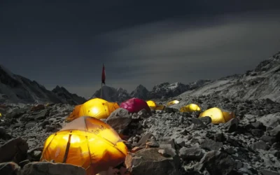
The Base Camp Atmosphere – Expedition Tents, Flags and Glacier
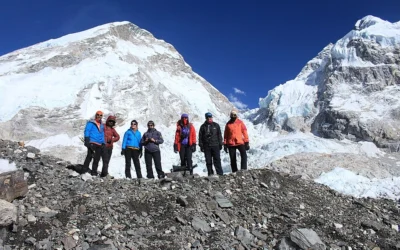
South Base Camp during the spring climbing season hosts between 500 and 1,000 people across dozens of expedition teams from 20 to 30 countries. The camp stretches 2 kilometres along the Khumbu Glacier moraine with colour-coded expedition tent clusters, equipment depots, kitchen tents, medical stations, and satellite communication arrays. Prayer flag lines connect tent poles across the camp, installed during the Puja ceremony that every expedition team performs before beginning their climb. The scale of human activity at this altitude is inseparable from why Everest Base Camp is famous as a destination in its own right, independent of the summit view question.
The Best Place to See Everest on the EBC Trek – Kala Patthar
Kala Patthar Altitude, Location and Trail Details
Kala Patthar stands at 5,644 metres on the southern flank of Pumori, 1.5 kilometres north of Gorakshep village. The name means “black rock” in Nepali, referring to the dark schist outcrop that forms the summit. The standard trekking high point is marked at 5,545 metres on most trail maps, with the true summit requiring a short scramble on loose rock above this point.
The trail from Gorakshep to Kala Patthar gains 314 metres of altitude over 1.5 kilometres and takes 1.5 to 2.5 hours at altitude depending on fitness and acclimatisation. The path is well-marked and does not require technical climbing equipment at any point. Most trekkers on the standard EBC itinerary climb Kala Patthar either the afternoon before or the morning after their Base Camp visit, with the majority choosing the pre-dawn ascent for sunrise views.
Sunrise vs Sunset at Kala Patthar – Which Is Better?
Sunrise at Kala Patthar produces the most photographed Everest view in the world. The first light of day strikes Everest’s summit pyramid from the east, turning the snow and ice from grey to gold to white over approximately 20 minutes as the sun clears the horizon. The Rongbuk Glacier on the Tibetan side of the peak reflects secondary light onto the summit’s western face, creating a three-dimensional illumination effect visible from Kala Patthar’s viewing position.
Sunset offers warmer light on the southwestern faces of Everest, Lhotse, and Nuptse, with alpenglow effects on clear evenings that turn the peaks deep orange and red in the 20 minutes before the sun drops below the Pumori ridge. Cloud build-up, more common in the afternoon than the morning on most days in the Khumbu, makes sunrise statistically more reliable for clear views. Trekkers with a single opportunity should choose sunrise. Trekkers with two days at Gorakshep should attempt both.
What Exactly You See from Kala Patthar
From Kala Patthar’s summit at 5,644 metres, Mount Everest’s summit pyramid is visible above the South Col at a distance of approximately 10 kilometres. The view shows the upper 1,200 metres of Everest’s southwestern face, including the South Col at 7,906 metres, the Southeast Ridge leading to the summit at 8,849 metres, and the characteristic plume of wind-blown snow that extends from the summit on most days. Pumori (7,161m) rises directly behind the viewing position to the north. Cho Oyu (8,188m), the world’s sixth highest mountain, is visible to the northwest at a distance of 28 kilometres. Lhotse’s complete south face is visible to the southeast.
Other Viewpoints Where You Can See Everest on the Trek
| Viewpoint | Altitude | Distance from EBC | Everest View | Best Time |
| Kala Patthar | 5,644m | 5km | Summit + upper SW face | Sunrise |
| Gorakshep village | 5,164m | 3km | Partial summit | Morning |
| Lobuche East Base | 4,940m | 8km | Summit visible | Morning |
| Thukla Pass (Dughla) | 4,620m | 12km | Summit distant | Morning |
| Tengboche Monastery | 3,860m | 24km | Summit with ridge | Morning |
| Namche Bazaar viewpoint | 3,440m | 38km | Summit distant | Clear mornings |
Tengboche Monastery at 3,860 metres provides one of the most contextually rich Everest views on the entire trek. The summit appears above the Nuptse-Lhotse ridge at a distance of 24 kilometres, framed by rhododendron forest in spring and the monastery’s prayer flag lines throughout the year. The monastery, rebuilt after a 1989 fire, is the most significant Buddhist monastery in the Khumbu region and adds a cultural dimension to the mountain view that Kala Patthar’s bare ridge cannot match. Trekkers planning the full approach should review the complete Everest Base Camp route guide to understand where each of these viewpoints falls within the standard itinerary.
North Base Camp in Tibet – Where Everest Is Fully Visible
How North Base Camp Differs from South Base Camp
North Everest Base Camp sits at 5,150 metres on the Rongbuk Glacier in Tibet’s Tingri County, 214 metres lower than South Base Camp in Nepal. The Tibetan base camp faces Everest’s North Face directly, with no intervening ridge or neighbouring peak to obstruct the view. From the camp’s main viewpoint, Everest’s complete north wall rises 3,699 metres in an unbroken vertical sweep from the glacier to the summit. The Northeast Ridge, the North Face, and the summit pyramid are all visible simultaneously from a single standing position at North Base Camp.
Access to North Base Camp requires a Tibet travel permit, a China visa, and travel through Lhasa or directly overland from Nepal via the Friendship Highway. The route is closed periodically by Chinese authorities and is subject to political restrictions that make planning uncertain. The Rongbuk Monastery, at 4,980 metres the highest monastery in the world, sits 8 kilometres below North Base Camp and is included in most Tibetan Base Camp itineraries..
Tips for the Best Everest Views on the EBC Trek
Best Time of Day for Clear Views
Everest and the surrounding peaks produce their clearest views in the two hours after sunrise. Morning temperatures maintain atmospheric stability and limit the convective cloud formation that builds over the peaks from mid-morning onward. By 10 AM on most days in the Khumbu, cloud development begins on the southern faces of the high peaks. By early afternoon, summit views from Kala Patthar and lower viewpoints are frequently obscured.
Trekkers targeting Kala Patthar should depart Gorakshep between 4 and 5 AM to reach the summit before sunrise. This requires a headlamp, warm layers rated to -15°C or below, and careful footing on the rocky trail in darkness. The physical preparation required for this early start and the overall trek is covered in detail in the Everest Base Camp trek fitness requirements guide, which outlines exactly what conditioning work makes the Kala Patthar ascent manageable.
Best Season for Everest Visibility
October and November provide the most statistically reliable clear-sky conditions for Everest views on the EBC trek. The post-monsoon atmosphere carries minimal moisture, jet stream winds stabilise at high altitude, and the combination produces the clearest Himalayan views of the year. The Nepal Tourism Board records October as the month with the highest percentage of clear-sky days in the Khumbu region across all recorded years.
Spring from March to May offers the second most reliable window. Pre-monsoon conditions maintain clear mornings in most years, with cloud build-up becoming more pronounced from late April. The spring season coincides with the Everest climbing season, adding the expedition atmosphere at Base Camp to the visual experience of clear mountain views.
Is It Worth Trekking to EBC If You Cannot See Everest from There?
Everest Base Camp Trek attracts approximately 40,000 trekkers per year according to Nepal’s Department of Immigration records. The overwhelming majority of these trekkers know before departure that Everest is not visible from the camp itself. They trek to Base Camp anyway.
The EBC trek delivers five distinct experiences that justify the 130 kilometre round trip from Lukla regardless of the summit view question. The Khumbu Icefall observation from Base Camp provides a direct encounter with one of the world’s most technically dangerous and visually extraordinary glacial features. Kala Patthar provides the best accessible Everest summit view on earth at trekking altitude. The Sherpa villages of Namche Bazaar, Tengboche, and Dingboche preserve a living culture shaped by six decades of high-altitude mountaineering history.
The trail passes through Sagarmatha National Park, a UNESCO World Heritage Site since 1979, containing some of the highest biodiversity in the Himalayan alpine zone. And the physical achievement of reaching 5,364 metres on foot over 8 to 12 days represents a personal milestone that most trekkers describe as transformative. For trekkers still weighing the decision, an honest assessment of whether Everest Base Camp is worth visiting addresses this question directly from the perspective of those who have completed the trek.
Conclusion
Mount Everest’s summit is not visible from South Base Camp in Nepal. Nuptse’s 7,861 metre western ridge blocks the direct line of sight from the camp floor at 5,364 metres to the summit at 8,849 metres. This geographical fact surprises many first-time trekkers but diminishes the Base Camp experience for almost none of them.
Kala Patthar at 5,644 metres provides the best accessible Everest summit view on the trek, with a direct line of sight to the upper 1,200 metres of the southwestern face at a distance of 10 kilometres. The standard EBC trek itinerary includes Kala Patthar as a natural complement to the Base Camp visit, and the two together deliver the complete Khumbu visual experience that 40,000 trekkers per year make the journey to find. For trekkers ready to begin planning the approach, the complete guide on how to get to Everest Base Camp covers every logistical step from Kathmandu to the glacier.
Frequently Asked Questions
Can you see the Everest summit from anywhere on the EBC trek without climbing Kala Patthar?
Yes. The Everest summit is visible from Gorakshep village at 5,164 metres on clear mornings, from the Thukla Pass at 4,620 metres, from Tengboche Monastery at 3,860 metres, and from the Namche Bazaar viewpoint at 3,440 metres. Each viewpoint offers a progressively more distant but still identifiable summit view. Kala Patthar at 5,644 metres provides the closest and clearest view on the standard trekking route.
How long does it take to climb Kala Patthar from Gorakshep?
The climb from Gorakshep at 5,164 metres to Kala Patthar’s trekking high point at 5,545 metres takes 1.5 to 2.5 hours depending on pace and acclimatisation level. The trail gains 381 metres over 1.5 kilometres on a well-marked rocky path. Descent to Gorakshep takes 45 minutes to 1.5 hours. Most trekkers spend 30 to 60 minutes at the summit before descending.
Is Kala Patthar difficult to climb?
Kala Patthar does not require technical climbing equipment or prior mountaineering experience. The trail is steep and the altitude at 5,545 metres means reduced oxygen availability that slows pace and increases breathlessness compared to lower elevations. Trekkers who have properly acclimatised during the standard EBC approach, spending rest days in Namche Bazaar and Dingboche, find Kala Patthar manageable as a day hike from Gorakshep.
What is the difference between Everest Base Camp and Everest Advanced Base Camp?
South Base Camp at 5,364 metres is the staging point for expeditions approaching Everest via the South Col route through the Khumbu Icefall. Advanced Base Camp, also called ABC, sits at 6,400 metres in the Western Cwm above the icefall and is accessible only to climbing expedition members with appropriate permits and equipment. ABC is not accessible to trekkers on standard EBC itineraries. The distance from Base Camp to the Everest summit covers the full vertical and horizontal distance between these points in detail.